The following is a work document that I’ve started to put
metrics into my world building exercises.
I’ve found that the existing projects that I already have some work on have
started to come apart due to a lack of clear metrics, so I don’t know if this
will be a patch, or the groundwork for all projects going forward.
All of my projects usually start with 3.5 base rules (the
D20 system, which is open source).
Humans, and therefore most races, move comfortably at
30ft/round (6 seconds) in tactical combat, 300 ft /minute (local), 3 miles an
hour (overland) and 24 miles a day (overland).
The source is PH pg. 162. There is
some variation with real life, not least of which 3.5 uses standardized Imperial
feet and miles as opposed to default-standard measures like meters, but it
works well enough for all medium sized creatures, it has well laid out tables
for creatures of bigger and smaller size, and it avoids the vexing question “What
is a meter on a planet other than Earth?”
The above list of measures is all mathematically consistent,
and assumes that the adventurers are putting in an 8 hour day. By the way, there are 5280 feet in a mile,
just so we are all square.
|
Time
|
Feet
|
Miles (ft/5280)
|
|
6 seconds
|
30
|
-
|
|
60 seconds (x10)
|
300
|
-
|
|
60 minutes (x60)
|
18,000
|
3 (give or take 0.4)
|
|
Day (x8)
|
144,000
|
24
|
There is no “forced march,” but there are numbers for hustle
(x2 on all metrics above) and run (which cannot be applied evenly to the
overland times).
Now for some token worldbuilding distances:
|
Distance
|
Distance, as per Google Maps
|
Time, as per Google Maps
|
Divided into 8 hour days
|
Time, as per 3.5
|
|
London, UK to York, UK
|
198 miles
|
65 hours
|
8.125
|
8.25
|
|
Dover, UK to Plymouth, UK
|
283 miles
|
92 hours
|
11.5
|
11.8
|
|
Paris, France to Brussels, Belgium
|
279 miles
|
57 hours (??? Google Maps)
|
7.125
|
11.6
|
Plunking names into Googlemaps, it occurs to me that some of
their numbers may not be entirely consistent.
I am revising by adding my own calculations based on the distance.
Result: Not sure what happened with the estimate for Paris
to Brussels, but 3.5 widely agrees with Google Maps estimates, except in this
one trip.
So, we have a more general idea of the distances
involved. Armies forcemarching from the
French capital to the Belgian would need to be in motion for about 6 days (12
days walking, 6 hustling) before automation in the infantry, and going any
faster the men won’t be in shape to do much fighting. But how often did early medieval armies march
such distances? What is the sense of
power that can be projected over distances?
Historical fiction author Carla
Nayland has already compiled some of the most frequent battle distances
that have come down to us preserved, including some excellent work with the
problems of the source materials (this is the Dark Age after all). Noting carefully that the sample is most
unlikely to be representative, she can name 12 battles conducted by Dark Age
English kingdoms, and amid them, 5 of those battles took place in distances 130
to 200 miles from the core.
As a theory to be tested, can we say Kingdoms can usually
express power effectively up to 5 days (125 miles) out, and that up to 8 days
out at need. 12 days Paris to Brussels,
by this theory, would be a little unusual.
We might have a problem with this suggestion, as other sources
seem to suggest 12 day journeys are common, though more and more in the High
Middle Ages, long journeys were seeing more fast marching to speed them up.
A Dark Age themed setting needs only extend political power
for a few days journey, and this is reinforced by the need to have the King’s
Court mobile. No one is going to make obeisance
to an empty chair, at least at this stage.
High Middle Ages and later settings tend to favour cities more readily,
and Kings and their courts are more sedentary, projecting power through
intermediaries. It is not until Louis XIV
that the King of France, France being an archtype of medieval living, felt
secure enough to administer the far flung regions of his Kingdom directly. This makes the 17th century state,
a manageable state, to be (as estimated by Google Maps) as follows.
|
Start at Versailles Palace
|
Distance to the Border Towns
|
Time to Border Towns
|
|
Valenciennes
|
217 km = 134.8 miles
|
45 h or 5.6 days
|
|
Metz
|
331 km = 205.7
|
66 h or 8.25
|
|
Strasbourg
|
461 km = 286.5 miles
|
95 h or 11.9 days
|
|
Grenoble
|
539 km = 334.9 miles
|
112 h or 14 days
|
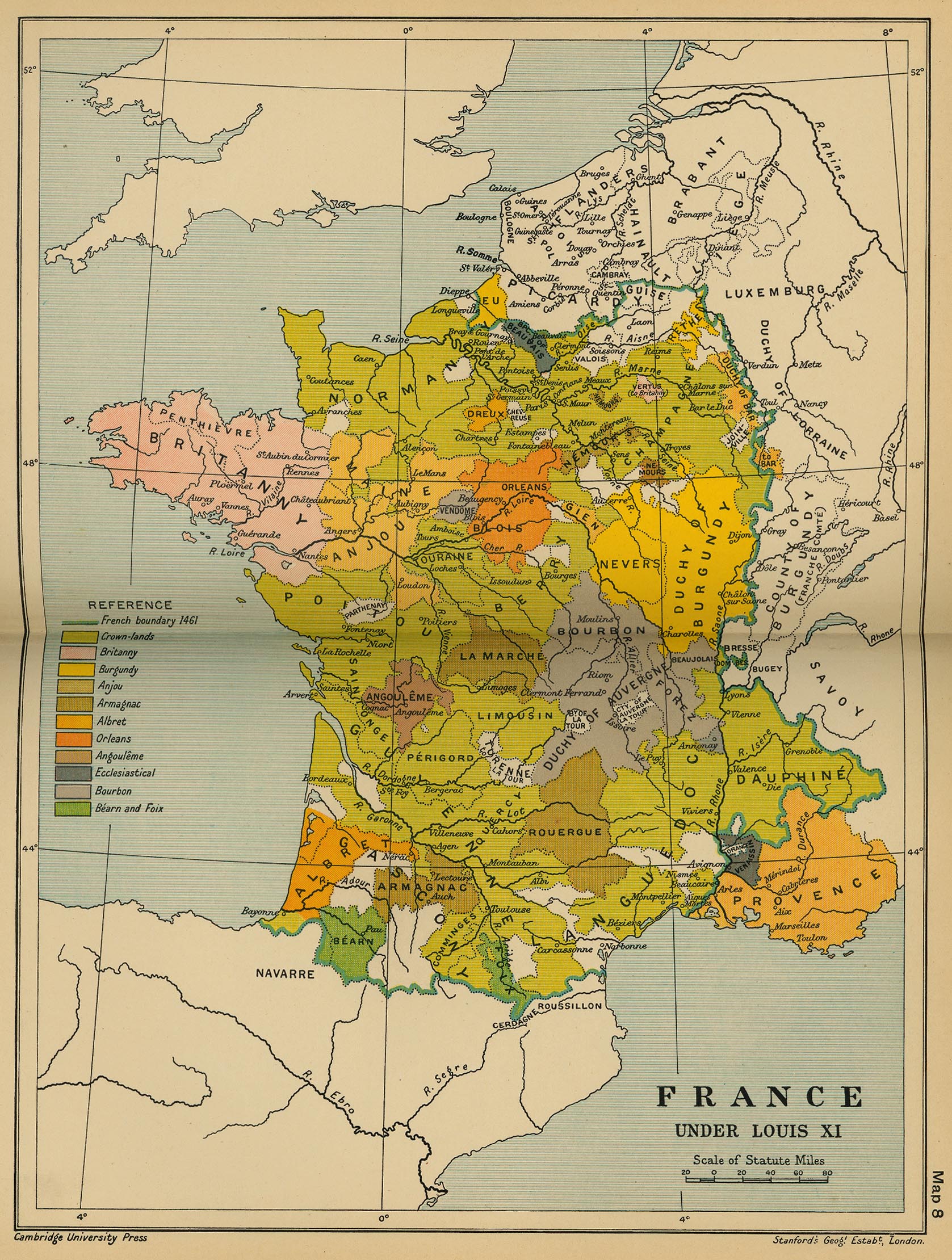
Before that time, Frence noble families ruled in the name of
their King, such as this map below shows, in the time of Louis XI in 1461.
The following maps are from "The Cambridge Modern
History Atlas" edited by Sir Adolphus William Ward, G.W. Prothero, Sir
Stanley Mordaunt Leathes, and E.A. Benians. Cambridge University Press; London.
1912. Users can access the index to
locate place names within the atlas.
I rather favor this build: France sets its capital 6 days
from its border, Begium does the same, and so it takes 12 days to travel from
Brussels to Paris and vice and versa. 6
days to prepare for an invasion is taken as the nominal amount of time
needed. England plays by a subtly
different set of rules, living as it
does behind geographic barriers, and aggressively exerting power on everyone on
its own side of the channel.
From Wikipedia:
|
Nation
|
Land Area
|
|
France
|
246,201 sq mi
|
|
England
|
50,346 sq mi
|
|
Italy
|
116,347 sq mi
|
|
Spain
|
195,364 sq mi
|
|
Scotland
|
30,414 sq mi
|
|
Ireland
|
32,595 sq mi
|
|
Norway
|
148,718 sq m
|
|
Sweden
|
173,745 sq mi
|
|
Denmark
|
42,915.7 km
= 16,569.84 sq mi (excludes Greenland)
|
|
Germany (modern, united)
|
137,847 sq mi
|
|
Poland
|
120,696.41 sq mi
|
Nation and world builders could do worse than to use these
metrics to determine the size of their respective nations.
No comments:
Post a Comment